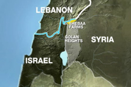
Since Israel’s unilateral withdrawal from southern Lebanon in May 2000, the Shebaa Farms sector of the Golan Heights has turned into a dangerous flashpoint of the Arab-Israeli conflict.
For the past 15 years, armed clashes between the Israeli army and Hezbollah have erupted periodically. Last month, in the most serious incident in years, two Israeli soldiers were killed and seven wounded by Hezbollah rocket fire in retaliation for an Israeli drone strike that killed several Hezbollah operatives and an Iranian general.
Israel’s pullout from Lebanon was certified by the United Nations under Resolution 425, but Hezbollah, in concert with the Lebanese government, claimed that it was incomplete. By their reasoning, Israel still occupied the Shebaa Farms, a 40-square kilometer enclave where the pre-1967 borders of Israel, Lebanon and Syria converged.
When Israel conquered the Golan in the Six Day War, this obscure mountainous redoubt was assumed to be Syrian territory. But in the wake of Israel’s withdrawal from Lebanon, the Lebanese prime minister laid claim to it, while Hezbollah initiated a series of violent border incidents to challenge Israel’s occupation.
Israel was surprised by Lebanon’s demand that Shebaa Farms be returned to its sovereignty. As far as Israel was concerned, this area had always been Syrian, not Lebanese.

It’s hardly surprising that Shebaa Farms, along with the adjacent region encompassing Mount Hermon and the village of Ghajar, is hotly contested. The boundaries of Palestine, Lebanon and Syria, having been unilaterally demarcated by Britain and France in the aftermath of World War I, were rejected by Arab nationalists and thus remain ambiguous and open to interpretation.
Asher Kaufman, a professor of history and peace studies at Notre Dame University, has written a first-rate book about this gnawing geopolitical problem. In Contested Frontiers in the Syria-Lebanon-Israel Region, published by the Woodrow Wilson Center Press in conjunction with Johns Hopkins University Press, he provides readers with a definitive account of the origins and consequences of the tri-border dispute, which is at the core of Israel’s struggle with Hezbollah.
“In order to understand the cartographic reality of May 2000,” he writes, “it is necessary to go back to the late 19th century and the beginning of the 20th, for it was then that the seeds of modern cartography of the region were first planted, and it is the maps of that period that were used in the 1920s to fix the boundaries among the three newly-created political entities: French-mandated Syria and Lebanon and British-mandated Palestine.”
According to Kaufman, an Israeli scholar, the Napoleonic invasion of Egypt in 1798 and the subsequent attempt to occupy Syria gave rise to the first modern maps of these countries. French and British mapping projects of Lebanon and Palestine in 1862 and 1871-1878 respectively were influential in determining the future boundaries between Syria, Lebanon and Israel.
These maps, however, were marred by what Kaufman describes as “irregularities.” Consequently, the 100-square kilometre area he focuses on in this informative and highly technical book was essentially up for grabs.
As he points out, the tri-border region — which contains one of the most important fresh water sources in the Middle East — was the scene of fierce fighting in the 1948, 1967 and 1973 Arab-Israeli wars and of constant border skirmishes pitting Israel against the Syrian army and Palestinian guerrilla groups.

In the spring of 2000, further tensions surfaced when the United Nations embarked on a project to demarcate the line of Israel’s withdrawal from southern Lebanon. As Kaufman observes, Hezbollah’s objective was not to resolve this thorny issue but to exploit it in order to perpetuate its conflict with Israel. In short, Hezbollah deliberately chose Shabaa Farms as “the banner of continued resistance against Israel,” he adds.
About 10 days after Israeli troops left southern Lebanon, Hezbollah fired a barrage of rockets at Israel, thereby launching the military confrontation that has flared periodically since 2000. Five months after this incident, Hezbollah kidnapped three Israeli soldiers, setting into motion yet another cycle of violence. In 2006, Hezbollah fired the opening shots that sparked the Second Lebanon War.
Bearing in mind that the old boundaries of Syria, Lebanon and Palestine had been drawn by European colonial powers, Kaufman points out that Israel’s withdrawal from southern Lebanon “instigated a war of maps, revealing a long history of cartographic disarray.” Elaborating on his thesis, he says, “Inaccurate French and British maps and imprecise border treaties perpetuated border anomalies that in turn were transferred to and perpetrated by the independent states of Syria, Lebanon and Israel.”
It seems clear that this conflict will flare and recede in the future, but its complexity can only be fully grasped if one possesses an understanding of the colonial machinations that unfolded in the Middle East decades ago. In Contested Frontiers, Kaufman explains what happened and why these events are still important today.